Gungal is basically a farming area located in the Hunter Region of New South Wales. Like many parts of Australia, its landscape is a mix of rugged natural beauty, open farmland and built heritage. The traditional custodians of the land are The Wonnarua.
.
THE WONNARUA PEOPLE
We would like to acknowledge the Wonnarua People who are the traditional custodians of this land. According to the Wonnarua Dreamtime the Hunter Valley was created by the great spirit, Baime (Byamee). “The land held the key to life’s secrets. (Man-kind).. was given the knowledge to read the land and for every rock, tree and creek he found an explanation for existence. He did not own the land, the land owned him.” (James Miller)
.
NATURAL LANDSCAPE
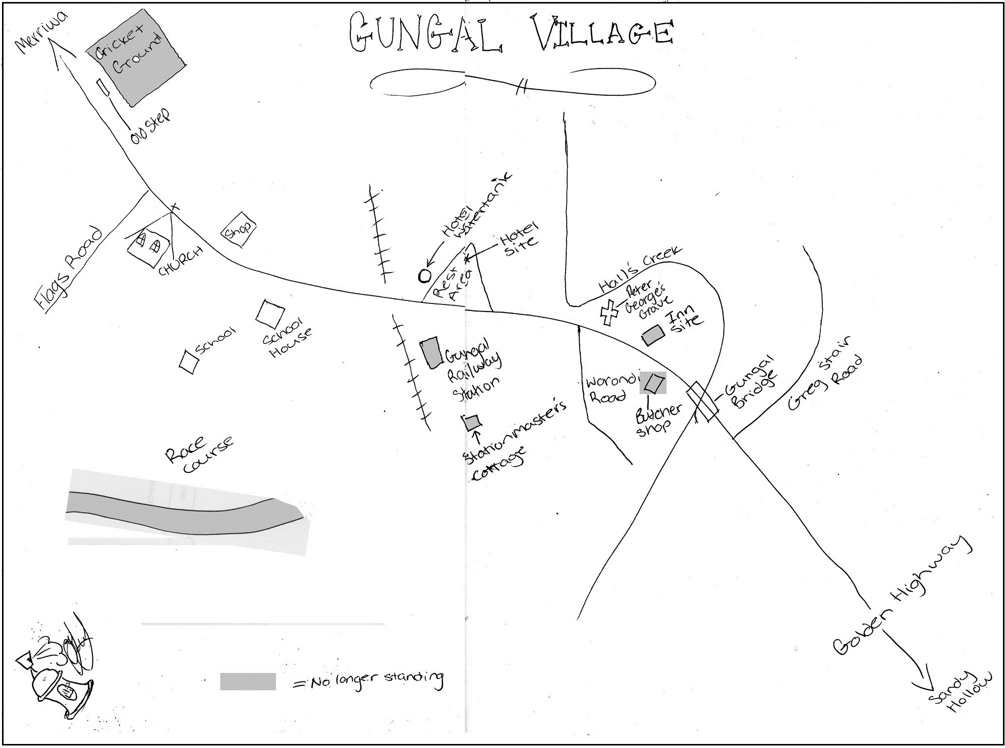
Gungal’s main water course is Hall’s Creek which winds its way down the valley to Sandy Hollow where it enters the Goulburn River. The valley is bounded to the north and south by rugged sandstone ridges that are honeycombed with caves. Animal life includes eastern grey kangaroos, wombats and a multitude of birds including turquoise parrots, wedge tailed eagles and glossy black cockatoos.

Mt Dangar
Driving westward along Flag’s Rd is the Worondi Rivulet which runs through a mix of farmland and hilly-bush. Shortly after crossing the Worondi, this road leaves the valley and passes through rolling country to Merriwa.
Eastward along Stair’s Rd is Giant’s Creek. You can continue driving through this scenic valley to Sandy Hollow.
Gungal’s Worondi Rd is a “no through road” but leads to a superb view of Mount Dangar, which is located between Baerami and Sandy Hollow. This basalt mountain was sited in 1826 by Henry Dangar who originally named it Mt Cupola.
Heading towards Merriwa along the Golden Highway is Ginger Beer Springs, so named because of spring water containing high amounts of solid non-organic elements. Apparently, the colourless and odourless water filters through a volcanic formation, gathering the solids in the process.
Further along the Golden Highway is ‘The Battery’. This formation is a natural phenomenon; clusters of exposed, almost horizontal, columns of basalt rock, that formed about 35 million years ago by volcanic lava cooling, and then fracturing.
.
FARMING LANDSCAPE
Most arable farmland is confined to the lower parts of the country, mainly around the water courses. The hills and ridges remain almost untouched because of steepness and large sandstone outcrops. Cattle farming is the main industry of Gungal, although there is a significant amount of cropping and horse production.
In earlier times wheat, sheep, dairying and grapes were produced but these were often at the mercy of drought. At one time, two large stations extended into Gungal:
- South Gundibri – located on the road to Merriwa where many community barn dances were held.
- Glenburnie – located on Flags Rd, which was once the home of Ben & Jessie Cowan.
Video: Gliding from Denman, Sandy Hollow, Gungal (at top of still) then finally to Merriwa:
.
BUILT LANDSCAPE
European settlement of the Gungal area mainly began in the 1860s and consisted of British and German immigrants. Gungal was once a busy village with a shop/post-office built 1901 and a school built 1913. These building still exist but are now private homes.
In earlier times the road through Gungal was used by teamsters to service western towns such as Merriwa, Cassilis and Dubbo. Because of the abundant fresh water in Hall’s Creek, Gungal was often used as a place to rest for the teamsters.
The heritage listed grave of Peter George is a reminder of this teamster era. After a day’s travel, Peter set-up camp on the evening of 6th Nov 1852 when he stepped on a Deaf Adder(sic). He died soon after and was buried near the bank of Hall’s Creek.

An Old Railway Crossing
Also because of its location on the main western road, Gungal became a Cobb & Co staging post. Morticed posts from the horse yards can be still seen on the western side of the highway.
The old tracks and cuttings of the Merriwa Railway can be seen running up to the Golden Highway at Gungal. The railway originally crossed the road near the rest area. The (now demolished) railway station and station master’s cottage were located just off the Golden Hwy on Worondi Road.
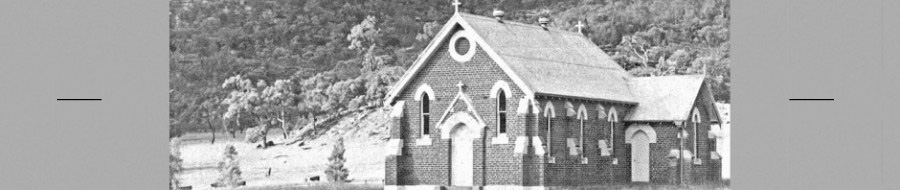
The most intact and important heritage item at Gungal is St Anthony of Padua Catholic Church. The church sits high on a ridge beside the Golden Highway and is surrounded by farmland. The church was built in 1911 and is still in use.
An old underground water tank which supplied Gungal’s Federal Hotel, still remains immediately north-west of the rest area. The Federal was a somewhat substantial brick building until destroyed in an explosive fire in 1935. After the fire the business was transferred to the nearby Tourist Hotel, Sandy Hollow.
.
An early view of Gungal, by Clarice Judge
